
Aerial Photography
Colorado Aerial Photography & Mapping - Denver & Rocky Mountain Region Learn MoreColorado & Nationwide
Headquartered in Metro Denver, Colorado we provide high quality aerial photography services in the Rocky Mountain and high plains regions. Nationwide service is available through our affiliation with a network of other professional aerial photographers.
Aircraft We Use
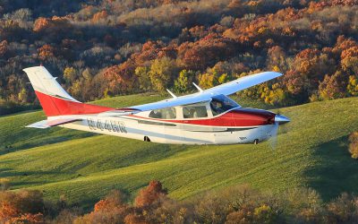
Our aircraft platforms range from helicopters and drones to our main aircraft which is a high altitude flying Cessna Turbo Centurion. This allows us to safely fly above the highest of Colorado’s mountains, for your next photo or video project.
Professional Grade Equipment
At Colorado Aerial Photography & Mapping, quality is one of our highest priorities. For that reason we only use professional grade equipment for our stabilized aerial video and photography services.
Aerial Photo & Video
Colorado Aerial Photography & Mapping offers aerial photography and video services for Metro Denver and the entire Rocky Mountain Region. We provide aerial imagery for Construction progress, Business & Industrial, Commercial Real Estate, Residential Real Estate Development, as well as Vertical Mapping.
Professional FAA licensed Airline Transport Pilot with over 37 years of flying experience and FAA certified UAS pilot.
+ Years Commercial Pilot
Professional Aerial Photographer
Inches Per Pixel Resolution
Business and Industrial
Colorado Aerial Photography and Mapping has photographed numerous properties among a wide variety of industries. We have worked with Fortune 500 companies, small businesses and everything in-between.
The types of subjects we have photographed are practically endless. Some examples include, construction sites, events, real estate, entire cities, roofs, power lines, utilities, pipeline routes, irrigation analysis, wildlife surveys, environmental surveys, traffic survey, roads and highways, bridges, crops, mines, power plants, railroad yards, schools, ski resorts, gun clubs, and water treatment facilities.
Construction Progress
Colorado Aerial Photography and Mapping has many years of experience serving the construction industry. Our construction progress photography service includes complete aerial photography coverage of your job site taken on a consistent schedule. Wide angle and close up views from all directions will be included. We understand that timely delivery of the imagery is vital and for that reason we always make sure the photos are available for download no later than the day after the flight. In special circumstances we can offer same day service.
We offer both drone and traditional aircraft service. One benefit of using the aircraft is that the camera is substantially higher resolution than any camera found on a drone. Additionally, some companies prefer to have photography taken from the aircraft so that there is no need to have a drone operator on site, possibly endangering him/herself or others.
Comercial & Residential Real Estate
We have been serving both commercial and residential real estate markets since 2003 so we know exactly what to deliver to satisfy the needs of our clients. For commercial real estate clients we recommend taking the photographs from our aircraft, which is not limited by the 400 foot FAA maximum altitude for drones. We understand that in commercial real estate, being able to showcase a property and the proximity to other businesses and highways is vital. Flying higher in our aircraft allows us to show your property and it’s surroundings to a much greater extent than a low flying drone.
Colorado Aerial Photography and Mapping has a catalog of stock photography of popular business areas around Denver and Colorado springs. For clients looking for a quick low cost solution we may have a stock photograph of your property already on hand.
Vertical Photography & Aerial Mapping
Vertical photography is captured with the camera mounted perpendicular to the ground so as to provide a straight down or “map view”. Our aircraft is specially equipped to capture this type of imagery. We are capable of photographing anything from small sites that can be cap-tured in a single image up to hundreds of square miles at resolutions as high as 3 inches per pixel.
We can utilize our drone to capture 3D imagery of small locations (approximately 100 acres or less). These images show topographical detail and the sides of buildings. Another use of the 3d imagery is measuring quantity of material in stock piles. Depth of quarries, mines, etc.
Colorado Aerial Photography and Mapping has a company pilot that is FAA licensed for all of our operations and fully insured. We understand the importance of our imagery to your business and will always prioritize safety, quality and consistent customer service.
Latest from Our Blog
Owner Kent Raney’s photography now on Fine Art America
Colorado Aerial Photography and Mapping owner Kent Raney has recently added some of his best images for sale on Fine Art America. All of the photos featured on the site are available in a multitude of formats for purchase. There are options for metal prints, canvas,...
Aircraft Vs. Drone: Which is Best?
Use Aircraft or Drone? Aircraft Vs. Drone, which is better? This is a common question brought up by new clients and the simple answer is; It depends. Colorado Aerial Photography and Mapping, LLC unlike most of the new entrants to this business, has the capability to...

Night Aerial Photography, Is it possible?
Over the past 18 years in business, we have had the occasional request for nighttime photos. Given the right circumstances this can be possible. A camera’s function is to take in visible light and record it. In the old days of film photography, the incoming light...